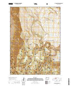
2020 Map of Little Honey Creek
USGS Topo · Published 2020About this map
Abert Rim dominates the western edge of this Lake County landscape, its steep escarpment dropping sharply toward the high desert floor. Located within the Fremont National Forest, this 2020 survey illustrates a complex hydrological network of seasonal lakes and numerous springs, such as Priday Lake and O'Hallihan Spring. The region is defined by its recreation and timber management infrastructure, featuring a dense grid of forest development roads and the Southern Oregon Intertie Trail. The map documents specific high-country landmarks like Washing Machine Flat and the ecological transition at White Pine Marsh. Drainage patterns are finely detailed along Little Honey Creek and Honey Cr, showing how water moves through the volcanic geography toward distant basins.
Find a feature on this map
37 named features on this map. Tap any name to fly to it.
Don’t see what you’re looking for? This feature index may not catch every label — zoom into the map to look around manually.
Map Details
Editions of this 2020 Little Honey Creek Map
This is the sole edition of this map. No revisions or reprints were ever made.
Other maps of this area

1955 · Klamath Falls
USGS Topo · 1:250,000

1958 · Klamath Falls
USGS Topo · 1:250,000

1964 · Crooked Creek Valley
USGS Topo · 1:24,000

1964 · Valley Falls
USGS Topo · 1:24,000

1966 · Coglan Buttes SE
USGS Topo · 1:24,000

1968 · Crook Peak
USGS Topo · 1:24,000
1968 · Drake Peak NE
USGS Topo · 1:24,000

1968 · Lake Abert South
USGS Topo · 1:24,000
1968 · Little Honey Creek
USGS Topo · 1:24,000
1968 · Cooper Draw
USGS Topo · 1:24,000