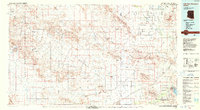
1988 Map of Little Horn Mountains
USGS Topo · Published 1988About this map
Kofa National Wildlife Refuge dominates the western portion of this desert landscape, where the Kofa Mountains rise abruptly from the surrounding basins. This 1980s era survey illustrates a transition from protected wildlands to large-scale military and recreational areas. The Yuma Proving Ground occupies a central swath of the territory, while the southeast corner features the course of the Gila River near Painted Rocks State Park. The region is defined by wide expanses like the Palomas Plain and Hyder Valley, which are dissected by an intricate network of seasonal drainage systems including Hoodoo Wash, Red Wash, and Centennial Wash. These desert washes, though often dry, dictate the movement and settlement patterns across the Little Horn Mountains and neighboring ranges during this period of Southwest development.
Find a feature on this map
33 named features on this map. Tap any name to fly to it.
Don’t see what you’re looking for? This feature index may not catch every label — zoom into the map to look around manually.
Map Details
Editions of this 1988 Little Horn Mountains Map
2 editions found
Other maps of this area

1927 · Hyder
USGS Topo · 1:62,500

1928 · Norton
USGS Topo · 1:62,500

1929 · Aztec
USGS Topo · 1:62,500

1929 · Norton
USGS Topo · 1:62,500

1930 · Stoval
USGS Topo · 1:62,500

1930 · Hyder
USGS Topo · 1:62,500

1942 · Yuma
USGS Topo · 1:250,000

1942 · Blythe
USGS Topo · 1:250,000

1942 · Vicksburg
USGS Topo · 1:250,000

1949 · Sentinel
USGS Topo · 1:62,500