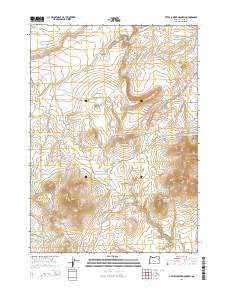
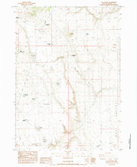
2014 Map of Little Juniper Mountain
USGS Topo · Published 2014About this map
Little Juniper Mountain rises above a high desert landscape characterized by an extensive network of water catchments and livestock reservoirs essential for survival in this arid section of Harney County. The map details the transition from the rugged drainage of Little Tank Canyon in the north to the broad expanse of Dobie Flat. Water management is the primary human imprint on the land, evidenced by numerous named features such as Jerrys Homestead Reservoir, Prospectors Reservoir, and Stovepipe Reservoir. Transportation through the area is limited to rugged tracks like Dry Valley Rd and Little Juniper Rd, while the Wagontire Airport provides a remote aerial link. The presence of Southside Spring and various waterholes like Cogans Waterhole underscores the historical and ongoing importance of reliable water sources in this remote ranching and grazing territory.
Find a feature on this map
44 named features on this map. Tap any name to fly to it.
Don’t see what you’re looking for? This feature index may not catch every label — zoom into the map to look around manually.
Map Details
Editions of this 2014 Little Juniper Mountain Map
This is the sole edition of this map. No revisions or reprints were ever made.
Other maps of this area

1955 · Burns
USGS Topo · 1:250,000

1958 · Burns
USGS Topo · 1:250,000

1959 · Burns
USGS Topo · 1:250,000

1980 · Wagontire Mtn West
USGS Topo · 1:24,000

1980 · Alec Butte
USGS Topo · 1:24,000

1980 · Wagontire Mtn East
USGS Topo · 1:24,000
1984 · Dry Valley Rim
USGS Topo · 1:24,000
1984 · Goose Egg Butte
USGS Topo · 1:24,000
1984 · Venator Canyon
USGS Topo · 1:24,000
1984 · Cox Canyon
USGS Topo · 1:24,000