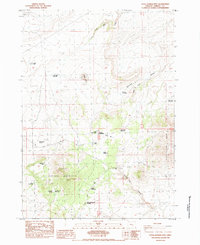
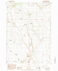
1984 Map of Little Juniper Mountain
USGS Topo · Published 1984About this map
Little Juniper Mountain dominates this high-desert landscape in Harney County, characterized by a complex network of seasonal water sources and ranching infrastructure. The map reveals the vital importance of water management in this arid region, documented through numerous named waterholes and reservoirs such as Brandts Waterhole, Hutton Waterhole, and Five Corners Reservoir. Human habitation is sparse, marked primarily by isolated structures like McDaniels Cabin and the site of Jerrys Homestead Reservoir. The terrain is defined by dry drainages and flats, including Dobie Flat, Wagon Draw, and the curiously named Smoke Out Canyon. This 1984 survey captures the area as it was managed for grazing, with 4WD tracks and unimproved roads providing the only access to remote points like Little Juniper Well and Stovepipe Reservoir.
Find a feature on this map
32 named features on this map. Tap any name to fly to it.
Don’t see what you’re looking for? This feature index may not catch every label — zoom into the map to look around manually.
Map Details
Editions of this 1984 Little Juniper Mountain Map
This is the sole edition of this map. No revisions or reprints were ever made.
Other maps of this area

1955 · Burns
USGS Topo · 1:250,000

1958 · Burns
USGS Topo · 1:250,000

1959 · Burns
USGS Topo · 1:250,000

1980 · Wagontire Mtn West
USGS Topo · 1:24,000

1980 · Alec Butte
USGS Topo · 1:24,000

1980 · Wagontire Mtn East
USGS Topo · 1:24,000
1984 · Dry Valley Rim
USGS Topo · 1:24,000
1984 · Goose Egg Butte
USGS Topo · 1:24,000
1984 · Venator Canyon
USGS Topo · 1:24,000
1984 · Cox Canyon
USGS Topo · 1:24,000