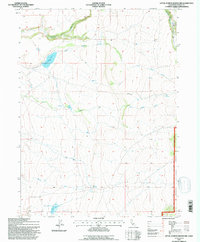
1993 Map of Little Juniper Reservoir
USGS Topo · Published 1996About this map
Modoc National Forest encompasses much of this high-elevation terrain in Northern California, where water management is central to the landscape's utility. The drainage system is defined by Little Juniper Creek and Big Juniper Creek, which feed into the Little Juniper Reservoir. To the south, Flournoy Reservoir serves as another significant catchment point, connected by a network of man-made irrigation infrastructure, including a prominent Ditch system. The presence of these reservoirs alongside natural features like Nelson Springs and Wall Springs illustrates the historical effort to capture and redirect runoff from the South Fork and Fitzhugh Creek for agricultural or livestock use in this arid region. The map provides a detailed view of the forest boundary and the relief of the surrounding hills, tracing the winding paths of seasonal watercourses like Romero Creek.
Find a feature on this map
12 named features on this map. Tap any name to fly to it.
Don’t see what you’re looking for? This feature index may not catch every label — zoom into the map to look around manually.
Map Details
Editions of this 1993 Little Juniper Reservoir Map
This is the sole edition of this map. No revisions or reprints were ever made.
Other maps of this area

1886 · Alturas
USGS Topo · 1:250,000

1892 · Alturas
USGS Topo · 1:250,000

1954 · Alturas
USGS Topo · 1:250,000

1958 · Alturas
USGS Topo · 1:250,000

1961 · Alturas
USGS Topo · 1:62,500

1962 · Alturas
USGS Topo · 1:250,000

1962 · Tule Mountain
USGS Topo · 1:24,000

1962 · Jess Valley
USGS Topo · 1:24,000

1962 · Likely
USGS Topo · 1:62,500

1963 · Little Juniper Reservoir
USGS Topo · 1:24,000