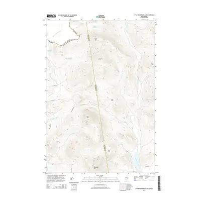
2014 Map of Little Kennebago Lake
USGS Topo · Published 2014About this map
Little Kennebago Lake and the upper reaches of the Kennebago River anchor this topographic survey along the international boundary where the Canada United States Of America border follows the height of land. The terrain is defined by prominent peaks including White Cap Mtn, Snow Mtn, and the distinctive Twin Mountains, which rise above a network of waterways and drainage basins. This 2014 representation of the Maine-Quebec borderlands shows a landscape primarily shaped by forestry and remote access, with specialized routes like Cupsuptic Tote RD, Big Canyon RD, and Wiggle Brook RD threading between the ridges. The map highlights the drainage divide separating the Atlantic-bound waters of Bear Brook and Sable Mill Brook from the Cupsuptic River system to the west. This data provides a clear look at the Oxford Co Franklin Co line as it intersects the remote Kennebago Divide.
Find a feature on this map
37 named features on this map. Tap any name to fly to it.
Don’t see what you’re looking for? This feature index may not catch every label — zoom into the map to look around manually.
Map Details
Editions of this 2014 Little Kennebago Lake Map
This is the sole edition of this map. No revisions or reprints were ever made.
Other maps of this area

1928 · Chain Lakes
USGS Topo · 1:48,000

1931 · Cupsuptic
USGS Topo · 1:48,000

1932 · Kennebago Lake
USGS Topo · 1:48,000

1932 · Arnold Pond
USGS Topo · 1:48,000

1932 · Chain Lakes
USGS Topo · 1:62,500

1934 · Cupsuptic
USGS Topo · 1:62,500

1935 · Kennebago Lake
USGS Topo · 1:62,500

1935 · Chain Lakes
USGS Topo · 1:62,500

1935 · Cupsuptic
USGS Topo · 1:62,500

1935 · Arnold Pond
USGS Topo · 1:62,500