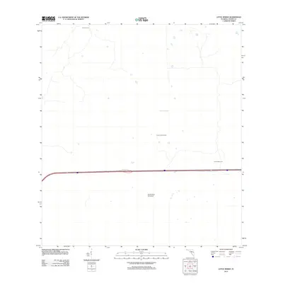
2012 Map of Little Marsh
USGS Topo · Published 2012About this map
Little Marsh defines this Collier County landscape as it appeared in the early 21st century, revealing a sparse and specialized pattern of human presence within the Florida Everglades. The sheet is primarily characterized by the vast expanses of the Big Cypress swamp, where named features often reflect the small, isolated camps used by local inhabitants. Distinctive outposts such as Pole Pen Camp, Charlie Cypress Camp, and Charlie Billie Camp are noted alongside the natural elevation of Charlie Fewl Hammock. These labels point to a lineage of land use tied to the region’s traditional inhabitants and seasonal hunters. The straight path of highway 84 provides the only major modern infrastructure, cutting through the wetlands and connecting this remote territory to the broader southern Florida network.
Find a feature on this map
6 named features on this map. Tap any name to fly to it.
Don’t see what you’re looking for? This feature index may not catch every label — zoom into the map to look around manually.
Map Details
Editions of this 2012 Little Marsh Map
This is the sole edition of this map. No revisions or reprints were ever made.
Other maps of this area

1956 · West Palm Beach
USGS Topo · 1:250,000

1957 · West Palm Beach
USGS Topo · 1:250,000

1958 · West Palm Beach
USGS Topo · 1:250,000

1958 · Sunniland
USGS Topo · 1:24,000

1959 · Miles City
USGS Topo · 1:24,000

1959 · Deep Lake
USGS Topo · 1:24,000

1974 · Immokalee 4 NW
USGS Topo · 1:24,000

1974 · Immokalee 1 SW
USGS Topo · 1:24,000

1974 · Immokalee 1 SE
USGS Topo · 1:24,000
1974 · Immokalee 4 SW
USGS Topo · 1:24,000