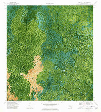
1974 Map of Immokalee 4 SW
USGS Topo · Published 1976About this map
Airplane Prairie stands out as a distinct clearing amid the dense, water-saturated landscape of the Florida Everglades during the mid-1970s. This orthophotomap, based on 1971 aerial photography, provides a rare visual of the intricate drainage patterns and cypress heads that define the region. The map highlights the linear footprint of human industry through the Old Railroad Grade, which cuts through the natural flow of the Deep Lake Strand and East Crossing Strand. These strands are essential corridors for water movement through the swamp, leading toward landmarks like Mud Lake and the interestingly named The Bamboos. The combination of photographic detail and topographic labeling offers a clear view of how transportation infrastructure was imposed upon this complex subtropical environment.
Find a feature on this map
6 named features on this map. Tap any name to fly to it.
Don’t see what you’re looking for? This feature index may not catch every label — zoom into the map to look around manually.
Map Details
Editions of this 1974 Immokalee 4 SW Map
3 editions found
Other maps of this area

1956 · Miami
USGS Topo · 1:250,000

1956 · West Palm Beach
USGS Topo · 1:250,000

1957 · West Palm Beach
USGS Topo · 1:250,000

1958 · West Palm Beach
USGS Topo · 1:250,000

1958 · Miami
USGS Topo · 1:250,000

1959 · Miles City
USGS Topo · 1:24,000

1959 · Deep Lake
USGS Topo · 1:24,000

1972 · Monroe Station NE
USGS Topo · 1:24,000

1972 · Burns Lake
USGS Topo · 1:24,000

1972 · Ochopee
USGS Topo · 1:24,000