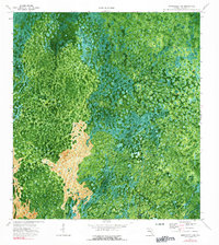
1974 Map of Immokalee 4 SW
USGS Topo · Published 1991About this map
Airplane Prairie and the sprawling wetland networks of the Florida Everglades dominate this orthophotomap, which was prepared from 1971 aerial photography and field checked in 1974. The landscape is characterized by its complex hydrology, featuring linear cypress strands like Deep Lake Strand and East Crossing Strand that channel water through the limestone and muck soils. Small hammocks and island-like clusters of vegetation punctuate the terrain, including the distinctly named The Bamboos and the small pocket of Mud Lake. The imagery reveals a nearly roadless wilderness at this time, providing an important record of Collier County before significant modern drainage or development patterns altered the natural sheet-flow of the Big Cypress region.
Find a feature on this map
5 named features on this map. Tap any name to fly to it.
Don’t see what you’re looking for? This feature index may not catch every label — zoom into the map to look around manually.
Map Details
Editions of this 1974 Immokalee 4 SW Map
3 editions found
Other maps of this area

1956 · Miami
USGS Topo · 1:250,000

1956 · West Palm Beach
USGS Topo · 1:250,000

1957 · West Palm Beach
USGS Topo · 1:250,000

1958 · West Palm Beach
USGS Topo · 1:250,000

1958 · Miami
USGS Topo · 1:250,000

1959 · Miles City
USGS Topo · 1:24,000

1959 · Deep Lake
USGS Topo · 1:24,000

1972 · Monroe Station NE
USGS Topo · 1:24,000

1972 · Burns Lake
USGS Topo · 1:24,000

1972 · Ochopee
USGS Topo · 1:24,000