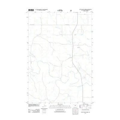
2012 Map of Little Nasty Creek
USGS Topo · Published 2012About this map
The S Fork Grand River meanders across this rural Perkins County landscape, serving as the primary drainage for several smaller watercourses like Duck Cr and Murphy Cr. This area of northwestern South Dakota is characterized by a sparse network of section-line roads, including Holland Center Rd and Divide Rd, which navigate the open terrain near the prominent Pinnacle landmark. Genealogy researchers will find the Fredlund Cem located along the eastern edge of the quadrangle, a significant site for tracing family history in this ranching region. The eponymous Little Nasty Cr winds south toward the river, accompanied for a stretch by Little Nasty Creek Rd, illustrating the traditional reliance of transportation corridors on natural geographic features in the plains.
Find a feature on this map
10 named features on this map. Tap any name to fly to it.
Don’t see what you’re looking for? This feature index may not catch every label — zoom into the map to look around manually.
Map Details
Editions of this 2012 Little Nasty Creek Map
This is the sole edition of this map. No revisions or reprints were ever made.
Other maps of this area

1954 · Lemmon
USGS Topo · 1:250,000

1957 · Lemmon
USGS Topo · 1:250,000

1983 · Grandmas Butte
USGS Topo · 1:24,000

1983 · Cow Butte SE
USGS Topo · 1:24,000

1983 · Lodgepole SE
USGS Topo · 1:24,000

1983 · Prairie City NE
USGS Topo · 1:24,000

1983 · Square Top Butte
USGS Topo · 1:24,000

1983 · Cole Dam
USGS Topo · 1:24,000

1983 · Little Nasty Creek
USGS Topo · 1:24,000
1983 · Prairie City
USGS Topo · 1:24,000