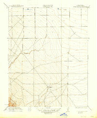
1923 Map of Little Panoche
USGS Topo · Published 1947About this map
Little Panoche Creek winds through this arid landscape of western Fresno County, providing a vital watercourse through the foothills of the Panoche Hills. Surveyed in the early 1920s, the map reveals an area defined by sparse industrial development and extensive topography. The presence of an Oil Pumping Station south of the creek highlights the early 20th-century energy infrastructure that began to dot the San Joaquin Valley’s western edge. Beyond this industrial marker, the terrain is characterized by a network of ranch roads and surveying benchmarks, reflecting the remote ranching and prospecting character of the era before major agricultural expansion or modern highway development transformed the region.
Find a feature on this map
3 named features on this map. Tap any name to fly to it.
Don’t see what you’re looking for? This feature index may not catch every label — zoom into the map to look around manually.
Map Details
Editions of this 1923 Little Panoche Map
2 editions found

Other maps of this area

1913 · Panoche
USGS Topo · 1:125,000

1921 · Laguna Seca Ranch
USGS Topo · 1:31,680

1921 · Tierra Loma School
USGS Topo · 1:31,680

1922 · Oxalis
USGS Topo · 1:31,680

1922 · Charleston School
USGS Topo · 1:31,680

1922 · Dos Palos
USGS Topo · 1:31,680

1922 · Chaney Ranch
USGS Topo · 1:31,680

1923 · Laguna Seca Ranch
USGS Topo · 1:31,680

1923 · Wisdom Well
USGS Topo · 1:31,680

1923 · Tierra Loma School
USGS Topo · 1:31,680