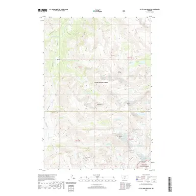
2020 Map of Little Park Mountain
USGS Topo · Published 2020About this map
Custer National Forest and Gallatin National Forest meet in this high-altitude corner of Park County, where the Beartooth Mountains dominate the landscape. The geography is defined by its glacial activity, with both the Wolf Glacier and Grasshopper Glacier feeding a network of high-country lakes such as Wolf Lakes, Grasshopper Lakes, and Courthouse Lake. The Stillwater River and its branches, including the Main Stillwater River and W. Fork Stillwater River, drain the eastern slopes through deep valleys. High peaks like Iceberg Peak, Sawtooth Mtn, and Storm Mtn create a jagged horizon, while the relatively level stretch of Big Park offers a rare break in the vertical relief. The map provides a precise view of these remote alpine systems before further glacial recession alters the landscape, marking the transition between major forest preserves.
Find a feature on this map
54 named features on this map. Tap any name to fly to it.
Don’t see what you’re looking for? This feature index may not catch every label — zoom into the map to look around manually.
Map Details
Editions of this 2020 Little Park Mountain Map
This is the sole edition of this map. No revisions or reprints were ever made.
Other maps of this area

1891 · Livingston
USGS Topo · 1:250,000

1893 · Livingston
USGS Topo · 1:250,000

1898 · Granite Mountain District
USGS Topo · 1:125,000

1932 · Nye No 2
USGS Topo · 1:48,000

1939 · Mt Wood
USGS Topo · 1:62,500

1941 · Mt. Wood
USGS Topo · 1:62,500

1941 · Mt Douglas
USGS Topo · 1:62,500

1942 · Cutoff Mtn
USGS Topo · 1:62,500

1943 · Mt Douglas
USGS Topo · 1:62,500

1944 · Cutoff Mtn
USGS Topo · 1:62,500