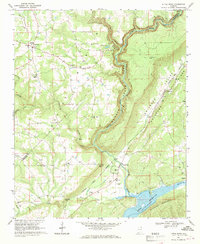
1967 Map of Little River
USGS Topo · Published 1969About this map
Little River Canyon dominates this 1967 survey, carving a deep gorge through the plateau of Northeast Alabama. The map documents a landscape defined by sharp vertical relief, from the heights of Shinbone Ridge and Saltcellar Ridge down to the shores of Weiss Reservoir. Local life in this era is centered around crossroads and rural churches, including Dog Town, Sigsbee, and Congo. Educational and religious landmarks like Ruhama Jr High Sch, Walkers Chapel, and Mt Moriah Ch provide specific points of interest for those researching local family roots. Further south, the map details the terrain around Daniels Gap and the waters of Wolf Creek and Spring Creek, while the Canyon Park Landing Strip reflects the mid-century development of the De Soto State Park area for regional visitors.
Find a feature on this map
50 named features on this map. Tap any name to fly to it.
Don’t see what you’re looking for? This feature index may not catch every label — zoom into the map to look around manually.
Map Details
Editions of this 1967 Little River Map
3 editions found
Other maps of this area

1893 · Fort Payne
USGS Topo · 1:125,000

1898 · Fort Payne
USGS Topo · 1:125,000

1900 · Fort Payne
USGS Topo · 1:125,000

1936 · Chavies
USGS Topo · 1:24,000

1946 · Portersville
USGS Topo · 1:24,000

1946 · Ft Payne
USGS Topo · 1:24,000
1946 · Chavies
USGS Topo · 1:24,000
1947 · Ft Payne
USGS Topo · 1:24,000
1947 · Portersville
USGS Topo · 1:24,000
1947 · Chavies
USGS Topo · 1:24,000