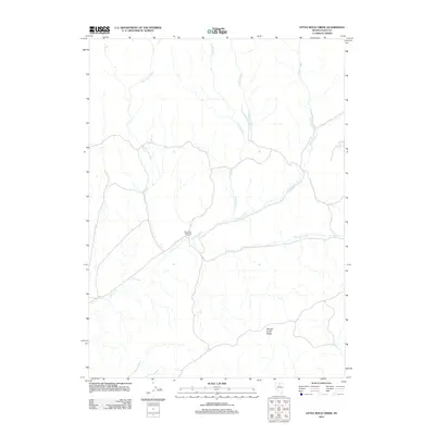
2012 Map of Little Rock Creek
USGS Topo · Published 2012About this map
Rock Creek Shearing Corral sits at the heart of this high-desert landscape in Elko County, marking a localized hub for the region's historic ranching and livestock activity. The topography is defined by a complex network of seasonal and perennial drainages, where Little Rock Creek, Coyote Creek, and Soldier Creek descend from the surrounding highlands to join the larger Rock Creek system. To the south, the terrain rises toward Willow Creek Ridge, overlooking the valley floor where Hot Springs emerge near the western boundary. This survey captures a remote segment of the Great Basin, where the infrastructure of the wool and sheep industry remained a primary landmark amidst a rugged hydraulic system that includes uniquely named tributaries like Toe Jam Creek and Trout Creek.
Find a feature on this map
9 named features on this map. Tap any name to fly to it.
Don’t see what you’re looking for? This feature index may not catch every label — zoom into the map to look around manually.
Map Details
Editions of this 2012 Little Rock Creek Map
This is the sole edition of this map. No revisions or reprints were ever made.
Other maps of this area

1955 · McDermitt
USGS Topo · 1:250,000

1956 · Mt. Blitzen
USGS Topo · 1:62,500

1959 · McDermitt
USGS Topo · 1:250,000

1965 · Willow Creek Reservoir
USGS Topo · 1:24,000

1965 · Squaw Valley Ranch
USGS Topo · 1:24,000
1970 · China Camp
USGS Topo · 1:24,000

1973 · Little Rock Creek
USGS Topo · 1:24,000

1974 · Soldier Cap
USGS Topo · 1:24,000

1974 · Burner Hills
USGS Topo · 1:24,000

1977 · Scraper Springs
USGS Topo · 1:24,000