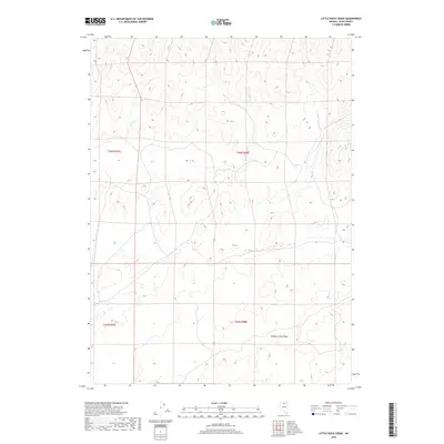
2018 Map of Little Rock Creek
USGS Topo · Published 2018About this map
Hot Springs and the elevated terrain of Willow Creek Ridge define this high-desert landscape in Elko County. The geography is marked by the drainages of Soldier Cr, which threads through the northern sections of the survey. This 2018 data represents the modern Public Land Survey System divisions, including sections of t40n r47e, t40n r48e, t39n r47e, and t39n r48e. The presence of geothermal features like the Hot Springs suggests a complex geological environment typical of the Great Basin, where water and relief are the primary indicators of land use and potential historical livestock grazing patterns.
Find a feature on this map
7 named features on this map. Tap any name to fly to it.
Don’t see what you’re looking for? This feature index may not catch every label — zoom into the map to look around manually.
Map Details
Editions of this 2018 Little Rock Creek Map
This is the sole edition of this map. No revisions or reprints were ever made.
Other maps of this area

1955 · McDermitt
USGS Topo · 1:250,000

1956 · Mt. Blitzen
USGS Topo · 1:62,500

1959 · McDermitt
USGS Topo · 1:250,000

1965 · Willow Creek Reservoir
USGS Topo · 1:24,000

1965 · Squaw Valley Ranch
USGS Topo · 1:24,000
1970 · China Camp
USGS Topo · 1:24,000

1973 · Little Rock Creek
USGS Topo · 1:24,000

1974 · Soldier Cap
USGS Topo · 1:24,000

1974 · Burner Hills
USGS Topo · 1:24,000

1977 · Scraper Springs
USGS Topo · 1:24,000