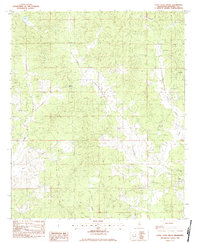
1983 Map of Little Sand Creek
USGS Topo · Published 1984About this map
Greensboro, once a significant county seat in the nineteenth century, is represented here through its surviving landmarks including Greensboro Ch and the Old Greensboro Cem. This 1983 provisional survey shows a landscape dominated by the branching headwaters of Calabrella Creek and Little Sand Creek, where small rural congregations and family burial grounds serve as the primary anchors for local history. The map records several such nodes, including Pine Forest Ch and Edward Springs Ch.
Find a feature on this map
24 named features on this map. Tap any name to fly to it.
Don’t see what you’re looking for? This feature index may not catch every label — zoom into the map to look around manually.
Map Details
Editions of this 1983 Little Sand Creek Map
This is the sole edition of this map. No revisions or reprints were ever made.
Other maps of this area

1953 · Walthall
USGS Topo · 1:62,500

1953 · West Point
USGS Topo · 1:250,000

1954 · Duck Hill
USGS Topo · 1:62,500

1958 · West Point
USGS Topo · 1:250,000

1963 · West Point
USGS Topo · 1:250,000

1966 · Kilmichael
USGS Topo · 1:24,000

1966 · Stewart
USGS Topo · 1:24,000

1966 · Tomnolen
USGS Topo · 1:24,000

1968 · Weir
USGS Topo · 1:62,500

1968 · Winona
USGS Topo · 1:62,500