
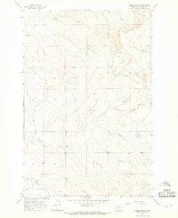
1965 Map of Little Sheep Mountain
USGS Topo · Published 1968About this map
Little Sheep Mountain dominates the landscape of this Prairie County terrain, defined by the intricate drainage systems of the Cherry Creek watershed. The 1965 survey reveals a sparsely populated ranching territory where life centered around isolated outposts like Devlin Ranch and the small settlement at Hawkins. The map traces the winding paths of the North Fork Cherry Creek and South Fork Cherry Creek as they carve through the high plains, illustrating the topographical challenges of 1960s Montana. Improved transport is represented by Cherry Creek Road and Caprock Road, which provided essential links between remote holdings and water sources. This document is particularly valuable for genealogists and local historians tracking the footprint of mid-century ranching families and the specific water rights associated with named drainages like Barney Creek and Whites Creek.
Find a feature on this map
14 named features on this map. Tap any name to fly to it.
Don’t see what you’re looking for? This feature index may not catch every label — zoom into the map to look around manually.
Map Details
Editions of this 1965 Little Sheep Mountain Map
This is the sole edition of this map. No revisions or reprints were ever made.
Other maps of this area

1953 · Miles City
USGS Topo · 1:250,000

1954 · Glendive
USGS Topo · 1:250,000

1957 · Miles City
USGS Topo · 1:250,000

1957 · Glendive
USGS Topo · 1:250,000

1958 · Miles City
USGS Topo · 1:250,000

1958 · Glendive
USGS Topo · 1:250,000

1965 · Heitz School
USGS Topo · 1:24,000

1965 · Twin Buttes School
USGS Topo · 1:24,000
1965 · Combs Ranch
USGS Topo · 1:24,000

1965 · Watkins SE
USGS Topo · 1:24,000