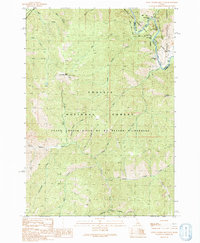
1990 Map of Little Soldier Mountain
USGS Topo · Published 1991About this map
The Middle Fork Salmon River carves through the eastern portion of this wilderness terrain, serving as a focal point for the region's remote access and river-based activity. Near the water, the Middle Fork Lodge and the Thomas Creek Landing Field mark critical points of human presence in a landscape otherwise defined by the Frank Church-River of No Return Wilderness. The map reveals the intricate drainage patterns of the Challis National Forest and Boise National Forest, with numerous named waterways like Lake Creek and Rapid River feeding into the main fork.
Find a feature on this map
37 named features on this map. Tap any name to fly to it.
Don’t see what you’re looking for? This feature index may not catch every label — zoom into the map to look around manually.
Map Details
Editions of this 1990 Little Soldier Mountain Map
This is the sole edition of this map. No revisions or reprints were ever made.
Other maps of this area

1930 · Casto
USGS Topo · 1:125,000

1957 · Challis
USGS Topo · 1:250,000

1960 · Challis
USGS Topo · 1:250,000

1961 · Greyhound Ridge
USGS Topo · 1:62,500

1962 · Norton Ridge
USGS Topo · 1:24,000

1963 · Challis
USGS Topo · 1:250,000

1963 · Pinyon Peak
USGS Topo · 1:24,000
1963 · Sliderock Ridge
USGS Topo · 1:24,000
1973 · Big Baldy
USGS Topo · 1:24,000
1973 · Pungo Mountain
USGS Topo · 1:24,000