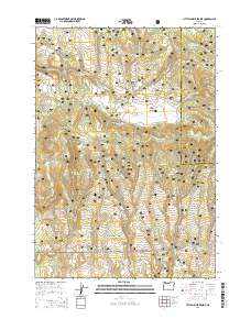
2014 Map of Little Summit Prairie
USGS Topo · Published 2014About this map
Ochoco National Forest defines this high-elevation landscape in Central Oregon, dominated by the sweeping expanse of Little Summit Prairie. This 2014 survey reveals a complex network of forest development roads, such as Arvid Nelson Rd and Roba Butte Rd, which facilitate access to remote water sources and peaks like Paulina Butte and Roba Butte. The terrain is characterized by numerous springs and small reservoirs, including Morgan Reservoir and Camp Reservoir, reflecting the area's importance for water management and livestock in a semi-arid timber environment. Local landmarks such as Round Meadow and Hewe Log Hollow provide specific points of interest for those tracing the history of land use and forestry in Crook County. The drainage patterns of Little Summit Creek and its tributaries, including Thornton Creek, illustrate the natural irrigation of these upland meadows.
Find a feature on this map
53 named features on this map. Tap any name to fly to it.
Don’t see what you’re looking for? This feature index may not catch every label — zoom into the map to look around manually.
Map Details
Editions of this 2014 Little Summit Prairie Map
This is the sole edition of this map. No revisions or reprints were ever made.
Other maps of this area

1932 · Dayville
USGS Topo · 1:125,000

1936 · Dayville
USGS Topo · 1:125,000

1955 · Bend
USGS Topo · 1:250,000

1955 · Canyon City
USGS Topo · 1:250,000

1957 · Bend
USGS Topo · 1:250,000

1958 · Bend
USGS Topo · 1:250,000

1959 · Canyon City
USGS Topo · 1:250,000

1966 · Keys Creek
USGS Topo · 1:24,000

1966 · Peterson Point
USGS Topo · 1:24,000

1966 · Antone
USGS Topo · 1:24,000