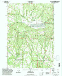
1992 Map of Little Summit Prairie
USGS Topo · Published 1997About this map
Little Summit Prairie sits as a central high-country clearing within the Ochoco National Forest, surrounded by a landscape defined by volcanic landforms and managed water resources. This 1992 revision, based on surveys from the early 1990s and aerial photography, reveals a complex network of springs and man-made impoundments essential for high-desert ranching and forest management. Features like Ruby Reservoir, Hook Reservoir, and Morgan Reservoir are strategically placed to capture seasonal runoff, while named springs such as Wilson Spring and Hewed Log Spring indicate the critical importance of reliable water points in this arid terrain. The map's topography is dominated by prominent volcanic features, including Paulina Butte and Roba Butte, which provide vertical contrast to the sprawling Timothy Meadow and Round Meadow. This area in Crook and Wheeler counties illustrates the transition from open grazing land to the forested ridges of Minifie Ridge.
Find a feature on this map
34 named features on this map. Tap any name to fly to it.
Don’t see what you’re looking for? This feature index may not catch every label — zoom into the map to look around manually.
Map Details
Editions of this 1992 Little Summit Prairie Map
This is the sole edition of this map. No revisions or reprints were ever made.
Other maps of this area

1932 · Dayville
USGS Topo · 1:125,000

1936 · Dayville
USGS Topo · 1:125,000

1955 · Bend
USGS Topo · 1:250,000

1955 · Canyon City
USGS Topo · 1:250,000

1957 · Bend
USGS Topo · 1:250,000

1958 · Bend
USGS Topo · 1:250,000

1959 · Canyon City
USGS Topo · 1:250,000

1966 · Keys Creek
USGS Topo · 1:24,000

1966 · Peterson Point
USGS Topo · 1:24,000

1966 · Antone
USGS Topo · 1:24,000