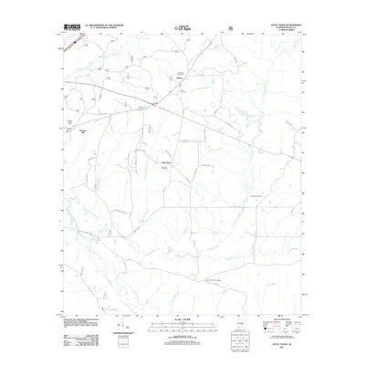
2011 Map of Little Texas
USGS Topo · Published 2011About this map
Alliance and Little Texas anchor this Macon County landscape, where small rural settlements are defined by an intricate network of waterways and local roads. The terrain is divided by several significant drainage systems, including Choctafaula Creek to the north and the winding Chewacla Creek and Opintlocco Creek to the south. The settlement pattern here is deeply rooted in local heritage, as evidenced by the numerous burial grounds scattered across the quadrangle, such as Mount Zion Cemetery, Union Cemetery, and Darlington Cemetery.
Find a feature on this map
45 named features on this map. Tap any name to fly to it.
Don’t see what you’re looking for? This feature index may not catch every label — zoom into the map to look around manually.
Map Details
Editions of this 2011 Little Texas Map
This is the sole edition of this map. No revisions or reprints were ever made.
Other maps of this area

1906 · Dadeville
USGS Topo · 1:125,000

1907 · Opelika
USGS Topo · 1:125,000

1909 · Opelika
USGS Topo · 1:125,000

1955 · Phenix City
USGS Topo · 1:250,000

1957 · Phenix City
USGS Topo · 1:250,000

1958 · Phenix City
USGS Topo · 1:250,000

1971 · Little Texas
USGS Topo · 1:24,000

1971 · Loachapoka
USGS Topo · 1:24,000

1971 · Tuskegee
USGS Topo · 1:24,000
1971 · Society Hill
USGS Topo · 1:24,000