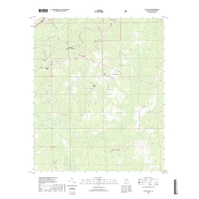
2018 Map of Little Texas
USGS Topo · Published 2018About this map
The northern reaches of the Tuskegee National Forest dominate this section of Macon County, where the historic Bartram trail and the Bold Destiny Horse Trail wind through a landscape defined by creek drainage systems. Small settlements such as Alliance and Little Texas serve as local hubs, characterized by a high concentration of community landmarks including the Little Texas Airport and numerous local burial grounds. The geography is deeply etched by watercourses like Choctafaula Cr and Chewacla Cr, which flow through the woodland and swampy lowlands. Genealogists and local historians will find significant value in the distribution of family and community sites, from the Hickory Grove Cem near Pleasant Hill to the Union Cem in the north. This 2018 survey provides a clear view of the rural road network, including Co Rd 69 and Co Rd 22, which connect these established timberlands and small Alabama communities.
Find a feature on this map
62 named features on this map. Tap any name to fly to it.
Don’t see what you’re looking for? This feature index may not catch every label — zoom into the map to look around manually.
Map Details
Editions of this 2018 Little Texas Map
This is the sole edition of this map. No revisions or reprints were ever made.
Other maps of this area

1906 · Dadeville
USGS Topo · 1:125,000

1907 · Opelika
USGS Topo · 1:125,000

1909 · Opelika
USGS Topo · 1:125,000

1955 · Phenix City
USGS Topo · 1:250,000

1957 · Phenix City
USGS Topo · 1:250,000

1958 · Phenix City
USGS Topo · 1:250,000

1971 · Little Texas
USGS Topo · 1:24,000

1971 · Loachapoka
USGS Topo · 1:24,000

1971 · Tuskegee
USGS Topo · 1:24,000
1971 · Society Hill
USGS Topo · 1:24,000