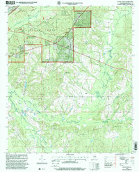
1998 Map of Little Texas
USGS Topo · Published 2001About this map
Tuskegee National Forest dominates the upper half of this landscape, where the Bartram National Recreation Trail and the Bedford V Cash Memorial Trail wind through managed timberlands. The settlement of Little Texas serves as a central hub for the surrounding rural community, which is anchored by several long-standing country churches, including Pine Grove Ch, Antioch Ch, and Union Ch. Down toward the southern reaches, the drainage basins of Chewacla Creek and Opinifocco Creek are dotted with numerous Gravel Pits, indicating the local extractive industry that defines the topography outside the forest boundaries. In the west, Pleasant Hill and Hickory Grove retain their local character through institutions like Hickory Grove Cem and Pleasant Hill Ch, while the Alabama State Forestry Commission and Tuskegee Ranger Station represent the active federal and state presence in this part of Macon County.
Find a feature on this map
27 named features on this map. Tap any name to fly to it.
Don’t see what you’re looking for? This feature index may not catch every label — zoom into the map to look around manually.
Map Details
Editions of this 1998 Little Texas Map
This is the sole edition of this map. No revisions or reprints were ever made.
Other maps of this area

1906 · Dadeville
USGS Topo · 1:125,000

1907 · Opelika
USGS Topo · 1:125,000

1909 · Opelika
USGS Topo · 1:125,000

1955 · Phenix City
USGS Topo · 1:250,000

1957 · Phenix City
USGS Topo · 1:250,000

1958 · Phenix City
USGS Topo · 1:250,000

1971 · Little Texas
USGS Topo · 1:24,000

1971 · Loachapoka
USGS Topo · 1:24,000

1971 · Tuskegee
USGS Topo · 1:24,000
1971 · Society Hill
USGS Topo · 1:24,000