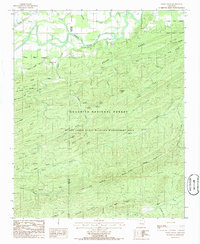
1985 Map of Little Texas
USGS Topo · Published 1986About this map
The Fourche La Fave River winds through the northern reaches of this mid-1980s terrain, marking a distinct boundary between the bottomlands and the dense forest to the south. The small settlement of Little Texas sits near the confluence of Oller Creek and Weaver Creek, serving as a rare point of habitation in a landscape otherwise dominated by the Ouachita National Forest. This era shows the heavy integration of conservation and land management, with the Muddy Creek State Wildlife Management Area covering a vast central portion of the quadrangle.
Find a feature on this map
59 named features on this map. Tap any name to fly to it.
Don’t see what you’re looking for? This feature index may not catch every label — zoom into the map to look around manually.
Map Details
Editions of this 1985 Little Texas Map
This is the sole edition of this map. No revisions or reprints were ever made.
Other maps of this area

1887 · Mount Ida #2
USGS Topo · 1:62,500

1890 · Mount Ida
USGS Topo · 1:125,000

1955 · Little Rock
USGS Topo · 1:250,000

1956 · Little Rock
USGS Topo · 1:250,000

1959 · Oden
USGS Topo · 1:62,500

1959 · Mount Ida
USGS Topo · 1:62,500

1960 · Little Rock
USGS Topo · 1:250,000

1960 · Gravelly
USGS Topo · 1:62,500
1960 · Parks
USGS Topo · 1:62,500

1964 · Little Rock
USGS Topo · 1:250,000