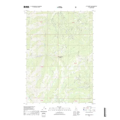
2020 Map of Little Trinity Lake
USGS Topo · Published 2020About this map
The Boise National Forest in Elmore County dominates this high-elevation terrain, defined by a complex network of drainages feeding into the Roaring River. This 2020 survey documents a landscape of dramatic verticality, from the peaks of Sheep Mountain in the west to the prominent spine of Trinity Ridge in the east. The southern portion of the quadrangle is punctuated by alpine water bodies, including Little Trinity Lake, Little Roaring River Lake, and the Twin Sisters Lakes, situated at the foot of the Trinity Mountains.
Find a feature on this map
67 named features on this map. Tap any name to fly to it.
Don’t see what you’re looking for? This feature index may not catch every label — zoom into the map to look around manually.
Map Details
Editions of this 2020 Little Trinity Lake Map
This is the sole edition of this map. No revisions or reprints were ever made.
Other maps of this area

1894 · Idaho Basin
USGS Topo · 1:125,000

1894 · Rocky Bar
USGS Topo · 1:125,000

1955 · Hailey
USGS Topo · 1:250,000

1959 · Hailey
USGS Topo · 1:250,000

1962 · Hailey
USGS Topo · 1:250,000
1964 · Featherville
USGS Topo · 1:24,000
1964 · Prairie
USGS Topo · 1:24,000
1964 · Trinity Mtn
USGS Topo · 1:24,000

1964 · Little Trinity Lake
USGS Topo · 1:24,000

1964 · Sheep Creek
USGS Topo · 1:24,000