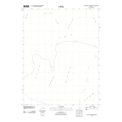
2010 Map of Little Wild Horse Mesa
USGS Topo · Published 2010About this map
Sinbad Country and the towering geological formations of the San Rafael Reef dominate this Emery County landscape. The topography is defined by a series of prominent elevated plateaus, including Little Wild Horse Mesa, Middle Wild Horse Mesa, and Big Wild Horse Mesa, which are separated by deep drainage systems. Drainage in the north and west is characterized by narrow passages such as Cistern Canyon, Bell Canyon, and the winding Little Wild Horse Canyon. In the southern portion of the quadrangle, Muddy Creek carves a path through the terrain, while Wild Horse Creek provides a natural corridor to the east. Transportation through this desert environment is limited to the unpaved track of Wild Horse Rd, illustrating the isolation of this corner of the San Rafael Swell.
Find a feature on this map
12 named features on this map. Tap any name to fly to it.
Don’t see what you’re looking for? This feature index may not catch every label — zoom into the map to look around manually.
Map Details
Editions of this 2010 Little Wild Horse Mesa Map
This is the sole edition of this map. No revisions or reprints were ever made.
Other maps of this area

1885 · San Rafael
USGS Topo · 1:250,000

1952 · Wild Horse
USGS Topo · 1:62,500

1953 · Temple Mtn
USGS Topo · 1:62,500

1954 · Stinking Springs Creek 4 SW
USGS Topo · 1:24,000

1954 · Stinking Spring Creek 3 NW
USGS Topo · 1:24,000

1954 · Stinking Spring Creek 3 SE
USGS Topo · 1:24,000

1954 · Stinking Spring Creek 4 NW
USGS Topo · 1:24,000

1954 · Stinking Spring Creek 3 SW
USGS Topo · 1:24,000
1954 · Stinking Spring Creek 3 NE
USGS Topo · 1:24,000

1954 · Mt. Ellen 1 NW
USGS Topo · 1:24,000