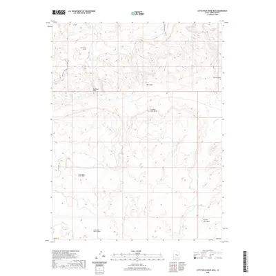
2020 Map of Little Wild Horse Mesa
USGS Topo · Published 2020About this map
The San Rafael Swell dominates this portion of Emery County, where the dramatic uplift meets the San Rafael Reef. This landscape is defined by its series of high, flat-topped mesas, including Little Wild Horse Mesa, Mid Wild Horse Mesa, and Big Wild Horse Mesa. The erosional patterns of the region are clearly visible through deeply cut features like Bell Canyon and Chute Canyon, which drain toward the south and east. A single named thoroughfare, Behind The Reef Road, provides access through the northwest corner of the map, tracing the base of the Swell's eastern edge. The topography is also shaped by intermittent watercourses like Wild Horse Creek and Muddy Creek, which cut through the lower elevations below the mesas. The arrangement of these features illustrates the classic geologic structure of the reef, where steeply tilted rock layers form a jagged barrier against the higher mesa country.
Find a feature on this map
12 named features on this map. Tap any name to fly to it.
Don’t see what you’re looking for? This feature index may not catch every label — zoom into the map to look around manually.
Map Details
Editions of this 2020 Little Wild Horse Mesa Map
This is the sole edition of this map. No revisions or reprints were ever made.
Other maps of this area

1885 · San Rafael
USGS Topo · 1:250,000

1952 · Wild Horse
USGS Topo · 1:62,500

1953 · Temple Mtn
USGS Topo · 1:62,500

1954 · Stinking Springs Creek 4 SW
USGS Topo · 1:24,000

1954 · Stinking Spring Creek 3 NW
USGS Topo · 1:24,000

1954 · Stinking Spring Creek 3 SE
USGS Topo · 1:24,000

1954 · Stinking Spring Creek 4 NW
USGS Topo · 1:24,000

1954 · Stinking Spring Creek 3 SW
USGS Topo · 1:24,000
1954 · Stinking Spring Creek 3 NE
USGS Topo · 1:24,000

1954 · Mt. Ellen 1 NW
USGS Topo · 1:24,000