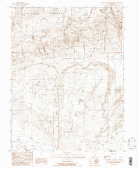
1988 Map of Little Wild Horse Mesa
USGS Topo · Published 1988About this map
San Rafael Reef anchors this 1980s topographic study, a dramatic uplift of stone that marks the eastern boundary of the San Rafael Swell. The landscape is defined by the high, flat-topped elevations of Little Wild Horse Mesa, Middle Wild Horse Mesa, and Big Wild Horse Mesa, which are separated by a complex network of deep drainages. To the north, the area opens into the appropriately named Sinbad Country, characterized by expansive terrain and intricate erosion patterns. This provisional map illustrates a wilderness area where water is scarce but powerful, seen in the winding paths of Little Wild Horse Canyon and Bell Canyon. The southern portion of the sheet captures the Emery Co Wayne Co line near the confluence of Muddy Creek and Wild Horse Creek, showing the primitive road network that provided access to these geological features before modern improvements.
Find a feature on this map
14 named features on this map. Tap any name to fly to it.
Don’t see what you’re looking for? This feature index may not catch every label — zoom into the map to look around manually.
Map Details
Editions of this 1988 Little Wild Horse Mesa Map
This is the sole edition of this map. No revisions or reprints were ever made.
Other maps of this area

1885 · San Rafael
USGS Topo · 1:250,000

1952 · Wild Horse
USGS Topo · 1:62,500

1953 · Temple Mtn
USGS Topo · 1:62,500

1954 · Stinking Springs Creek 4 SW
USGS Topo · 1:24,000

1954 · Stinking Spring Creek 3 NW
USGS Topo · 1:24,000

1954 · Stinking Spring Creek 3 SE
USGS Topo · 1:24,000

1954 · Stinking Spring Creek 4 NW
USGS Topo · 1:24,000

1954 · Stinking Spring Creek 3 SW
USGS Topo · 1:24,000
1954 · Stinking Spring Creek 3 NE
USGS Topo · 1:24,000

1954 · Mt. Ellen 1 NW
USGS Topo · 1:24,000