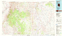
1987 Map of Littlefield
USGS Topo · Published 1988About this map
The Virgin River carves a deep path through northwestern Arizona, anchoring a landscape where water sources like Mokiac Spring and Lizard Spring were essential for early ranching and travel. This late-twentieth-century survey illustrates the sparse settlement patterns around Beaver Dam and Little Bend at the base of the Beaver Dam Mountains. The map reveals a network of high-desert infrastructure, from the Main Street valley road to the isolated Hidden Mines tucked into the southern plateaus.
Find a feature on this map
44 named features on this map. Tap any name to fly to it.
Don’t see what you’re looking for? This feature index may not catch every label — zoom into the map to look around manually.
Map Details
Editions of this 1987 Littlefield Map
2 editions found
Other maps of this area

1885 · St. George
USGS Topo · 1:250,000

1885 · Pioche
USGS Topo · 1:250,000

1886 · Kanab
USGS Topo · 1:250,000

1886 · Saint Thomas
USGS Topo · 1:250,000

1886 · Mt. Trumbull
USGS Topo · 1:250,000

1886 · Pioche
USGS Topo · 1:250,000

1886 · Kaibab
USGS Topo · 1:250,000

1891 · St. George
USGS Topo · 1:250,000

1892 · Mt. Trumbull
USGS Topo · 1:250,000

1893 · Saint Thomas
USGS Topo · 1:250,000