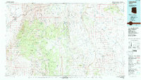
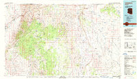
1987 Map of Littlefield
USGS Topo · Published 1988About this map
Littlefield and the nearby settlement of Frehner sit at the northwestern edge of this landscape, where the Virgin River emerges from The Narrows. This late-1980s data highlights a territory defined by massive topographic shifts, dominated by the Hurricane Cliffs and the sweeping Shivwits Plateau. The map records an era of remote land management, marked by numerous water sources critical for life in the high desert, such as Mormon Well, Lizard Spring, and Antelope Spring.
Find a feature on this map
97 named features on this map. Tap any name to fly to it.
Don’t see what you’re looking for? This feature index may not catch every label — zoom into the map to look around manually.
Map Details
Editions of this 1987 Littlefield Map
2 editions found
Other maps of this area

1885 · St. George
USGS Topo · 1:250,000

1885 · Pioche
USGS Topo · 1:250,000

1886 · Kanab
USGS Topo · 1:250,000

1886 · Saint Thomas
USGS Topo · 1:250,000

1886 · Mt. Trumbull
USGS Topo · 1:250,000

1886 · Pioche
USGS Topo · 1:250,000

1886 · Kaibab
USGS Topo · 1:250,000

1891 · St. George
USGS Topo · 1:250,000

1892 · Mt. Trumbull
USGS Topo · 1:250,000

1893 · Saint Thomas
USGS Topo · 1:250,000