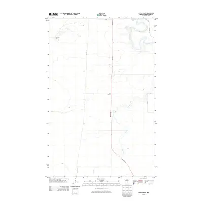
2013 Map of Littlefork SE
USGS Topo · Published 2013About this map
The Little Fork River winds through the northern portion of this Koochiching County landscape, characterized by its intricate oxbow loops and riparian lowlands. Dominating the western terrain, the Deer River Line establishes a long, straight north-south corridor through the timbered interior, while the centrally located Industrial Ave serves as the primary modern thoroughfare. Local landmarks of note include the Happy Land Lookout Tower situated on a topographical rise in the northwest, and the Cross River Hall, which anchors a segment of the river-crossed terrain further south. The Cross River bisects the area from southeast to northwest, creating a network of secondary drainage that defines the local hydrology. This 2013 survey illustrates the intersection of historical logging-era alignments, such as the Wisner Trl, with contemporary rural infrastructure.
Find a feature on this map
12 named features on this map. Tap any name to fly to it.
Don’t see what you’re looking for? This feature index may not catch every label — zoom into the map to look around manually.
Map Details
Editions of this 2013 Littlefork SE Map
This is the sole edition of this map. No revisions or reprints were ever made.
Other maps of this area

1919 · Happy Land
USGS Topo · 1:62,500

1919 · M
USGS Topo · 1:62,500

1954 · International Falls
USGS Topo · 1:250,000

1957 · International Falls
USGS Topo · 1:250,000

1958 · International Falls
USGS Topo · 1:250,000

1969 · Ericsburg NW
USGS Topo · 1:24,000

1969 · Ericsburg SW
USGS Topo · 1:24,000

1970 · Littlefork SE
USGS Topo · 1:24,000
1970 · Littlefork
USGS Topo · 1:24,000

1970 · Littlefork SW
USGS Topo · 1:24,000