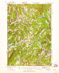
1932 Map of Littleton
USGS Topo · Published 1960About this map
Kirby Mtn Quarries and the branching lines of the Maine Central and Boston and Maine railroads define this early 1930s landscape along the border of Vermont and New Hampshire. The Connecticut River serves as the central artery, separating the townships of Waterford and Littleton. This survey captures the rural infrastructure of the era, documented through a dense network of one-room schoolhouses such as North Concord Sch, Texas Sch, and Slate Ledge Sch. The local economy is visible in the proximity of resource extraction and transit, with settlements like Miles Pond and East St Johnsbury situated at critical rail junctions. Further south, the terrain becomes more varied around Partridge Lake and Ogontz Lake, where small crossroads like Tinkerville and Barrett mark the transition into the White Mountain foothills.
Find a feature on this map
98 named features on this map. Tap any name to fly to it.
Don’t see what you’re looking for? This feature index may not catch every label — zoom into the map to look around manually.
Map Details
Editions of this 1932 Littleton Map
3 editions found
Other maps of this area

1900 · Whitefield
USGS Topo · 1:62,500

1920 · Guildhall
USGS Topo · 1:62,500

1929 · Moosilauke
USGS Topo · 1:62,500

1929 · Franconia
USGS Topo · 1:62,500

1931 · Guildhall
USGS Topo · 1:48,000

1931 · Littleton
USGS Topo · 1:62,500

1931 · Woodsville
USGS Topo · 1:48,000

1932 · Franconia
USGS Topo · 1:62,500

1932 · Littleton
USGS Topo · 1:48,000

1932 · Moosilauke
USGS Topo · 1:62,500