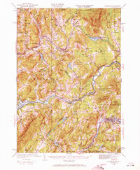
1932 Map of Littleton
USGS Topo · Published 1971About this map
The Connecticut River serves as the winding boundary between Vermont and New Hampshire in this early 1930s survey, anchoring a landscape defined by small mill towns and high-elevation quarries. Industry and transport are closely linked, with the Maine Central Railroad following the Moose River and Miles Pond through Concord, while the extraction of natural resources is evident at Kirby Mtn Quarries and Mining Hill.
Find a feature on this map
96 named features on this map. Tap any name to fly to it.
Don’t see what you’re looking for? This feature index may not catch every label — zoom into the map to look around manually.
Map Details
Editions of this 1932 Littleton Map
3 editions found
Other maps of this area

1900 · Whitefield
USGS Topo · 1:62,500

1920 · Guildhall
USGS Topo · 1:62,500

1929 · Moosilauke
USGS Topo · 1:62,500

1929 · Franconia
USGS Topo · 1:62,500

1931 · Guildhall
USGS Topo · 1:48,000

1931 · Littleton
USGS Topo · 1:62,500

1931 · Woodsville
USGS Topo · 1:48,000

1932 · Franconia
USGS Topo · 1:62,500

1932 · Littleton
USGS Topo · 1:48,000

1932 · Moosilauke
USGS Topo · 1:62,500