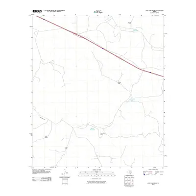
2010 Map of Live Oak Draw
USGS Topo · Published 2010About this map
North Llano River flows across the northern edge of this Sutton County landscape, a terrain defined by the complex drainage systems typical of the Edwards Plateau. These intermittent watercourses, including Tenmile Draw, Live Oak Draw, and Rattlesnake Draw, converge toward the river, illustrating the region's hydrological patterns where water is often concentrated in specific natural basins. Vital landmarks for ranching and local navigation are noted at Tenmile Waterhole and Eightmile Waterhole, indicating reliable points of surface water in an otherwise arid environment. Along the southern reaches, Bull Hollow and Eightmile Draw further mark the rugged limestone topography. The absence of established townsites underscores the rural, agricultural character of this portion of West Texas, where life and property boundaries are traditionally tied to these distinct draws and river access.
Find a feature on this map
8 named features on this map. Tap any name to fly to it.
Don’t see what you’re looking for? This feature index may not catch every label — zoom into the map to look around manually.
Map Details
Editions of this 2010 Live Oak Draw Map
This is the sole edition of this map. No revisions or reprints were ever made.
Other maps of this area

1893 · Rock Springs
USGS Topo · 1:125,000

1893 · Fort McKavett
USGS Topo · 1:125,000

1954 · Sonora
USGS Topo · 1:250,000

1958 · Sonora
USGS Topo · 1:250,000

1962 · Stewart Ranch
USGS Topo · 1:24,000
1962 · Bundy Ranch
USGS Topo · 1:24,000

1963 · Steen Lake
USGS Topo · 1:24,000

1963 · Harrison Ranch
USGS Topo · 1:24,000

1963 · Live Oak Draw
USGS Topo · 1:24,000

1963 · Buffalo Well SE
USGS Topo · 1:24,000