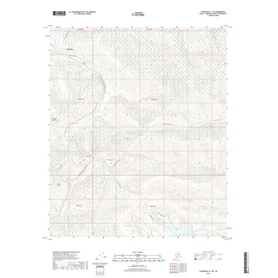
2017 Map of Livengood A-1 SW
USGS Topo · Published 2017About this map
The Chatanika River valley and its surrounding highlands dominate this part of the Fairbanks North Star Borough, where the modern transport corridor of the Steese Expressway Highway cuts through the legacy of the Interior's mining history. The drainage network is dense with gold-flecked names like Too Much Gold Cr, Deadwood Cr, and Bedrock Cr, reflecting the region's geological draw. High ground is anchored by Pedro Dome, a prominent summit surrounded by a web of specialized access routes including Pedro Dome Road and Fort Knox Road. These tracks, along with the Old Chatanika Road, illustrate how the landscape has been shaped by resource extraction and northern infrastructure. The map details the complex terrain where Fairbanks Cr and Fish Cr originate, providing a precise record of the upland topography before further contemporary development.
Find a feature on this map
38 named features on this map. Tap any name to fly to it.
Don’t see what you’re looking for? This feature index may not catch every label — zoom into the map to look around manually.
Map Details
Editions of this 2017 Livengood A-1 SW Map
This is the sole edition of this map. No revisions or reprints were ever made.
Other maps of this area

1945 · Livengood
USGS Topo · 1:250,000

1949 · Fairbanks D-1
USGS Topo · 1:62,500

1949 · Fairbanks D-2
USGS Topo · 1:62,500

1950 · Fairbanks
USGS Topo · 1:250,000

1951 · Fairbanks
USGS Topo · 1:250,000

1951 · Livengood
USGS Topo · 1:250,000

1952 · Fairbanks D-2
USGS Topo · 1:63,360
1952 · Fairbanks D-1
USGS Topo · 1:63,360

1952 · Fairbanks
USGS Topo · 1:250,000

1952 · Livengood A-2
USGS Topo · 1:63,360