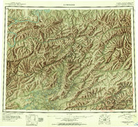
1945 Map of Livengood
USGS Topo · Published 1954About this map
Livengood and the gold-bearing drainages of the White Mountains anchor this mid-century survey, which details a landscape defined by placer mining and difficult travel. The northern reach is dominated by the Yukon River, where the site of Fort Hamlin (Aband) sits near the mouth of Hess Creek. Toward the southeast, a denser cluster of mining camps including Golden City, Chatanika, Cleary, and Vault reveals the footprint of early 20th-century interior Alaskan development. This territory is cross-cut by a mix of infrastructure, from the Elliott Highway to numerous segments of Winter Trail, Tractor Trail, and Sled Road. These transit routes highlight the seasonal nature of movement through the drainages of the Tolovana River and Beaver Creek, connecting remote claims like Discovery PUD and the Bend Shelter Cabin to the larger hubs of the Fourth Judicial Division.
Find a feature on this map
138 named features on this map. Tap any name to fly to it.
Don’t see what you’re looking for? This feature index may not catch every label — zoom into the map to look around manually.
Map Details
Editions of this 1945 Livengood Map
4 editions found
Other maps of this area

1945 · Livengood
USGS Topo · 1:250,000

1948 · Kantishna River
USGS Topo · 1:250,000

1949 · Fairbanks D-1
USGS Topo · 1:62,500

1949 · Fairbanks D-2
USGS Topo · 1:62,500

1949 · Fairbanks D-3
USGS Topo · 1:63,360

1949 · Fairbanks D-4
USGS Topo · 1:63,360

1950 · Fairbanks
USGS Topo · 1:250,000

1950 · Big Delta
USGS Topo · 1:250,000

1950 · Big Delta D-6
USGS Topo · 1:63,360

1950 · Fairbanks D-5
USGS Topo · 1:63,360