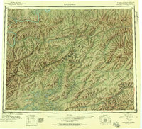
1945 Map of Livengood
USGS Topo · Published 1956About this map
Livengood and its surrounding gold-bearing creeks serve as the focal point for this interior Alaska survey, reflecting a landscape defined by the extraction of minerals and the challenges of subarctic transport. The drainage of Livengood Creek and Lillian Creek reveals a dense network of mining claims like Discovery Pup and Helen Gulch, accessible via the Elliott Highway. Further south, the map details the mining settlements of Chatanika, Meehan, and Golden City near the Fairbanks Meridian, where the industrial footprint of the early 20th century met the rising slopes of Pedro Dome.
Find a feature on this map
175 named features on this map. Tap any name to fly to it.
Don’t see what you’re looking for? This feature index may not catch every label — zoom into the map to look around manually.
Map Details
Editions of this 1945 Livengood Map
4 editions found
Other maps of this area

1945 · Livengood
USGS Topo · 1:250,000

1948 · Kantishna River
USGS Topo · 1:250,000

1949 · Fairbanks D-1
USGS Topo · 1:62,500

1949 · Fairbanks D-2
USGS Topo · 1:62,500

1949 · Fairbanks D-3
USGS Topo · 1:63,360

1949 · Fairbanks D-4
USGS Topo · 1:63,360

1950 · Fairbanks
USGS Topo · 1:250,000

1950 · Big Delta
USGS Topo · 1:250,000

1950 · Big Delta D-6
USGS Topo · 1:63,360

1950 · Fairbanks D-5
USGS Topo · 1:63,360