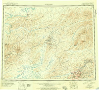
1945 Map of Livengood
USGS Topo · Published 1956About this map
The Yukon River carves across the northern reaches of this interior Alaskan landscape, which transitioned into a significant mining and transportation hub by the mid-1940s. Centered around the settlement of Livengood, the map illustrates a network of essential infrastructure including a Tractor Trail, Sled Road, and the emerging Steese Highway. This region's history is marked by the shifting tides of the gold rush, evidenced by the presence of mining-era towns like Golden City, Eldorado, and Meehan, while the river post at Fort Hamlin is already noted as abandoned.
Find a feature on this map
148 named features on this map. Tap any name to fly to it.
Don’t see what you’re looking for? This feature index may not catch every label — zoom into the map to look around manually.
Map Details
Editions of this 1945 Livengood Map
4 editions found
Other maps of this area

1945 · Livengood
USGS Topo · 1:250,000

1948 · Kantishna River
USGS Topo · 1:250,000

1949 · Fairbanks D-1
USGS Topo · 1:62,500

1949 · Fairbanks D-2
USGS Topo · 1:62,500

1949 · Fairbanks D-3
USGS Topo · 1:63,360

1949 · Fairbanks D-4
USGS Topo · 1:63,360

1950 · Fairbanks
USGS Topo · 1:250,000

1950 · Big Delta
USGS Topo · 1:250,000

1950 · Big Delta D-6
USGS Topo · 1:63,360

1950 · Fairbanks D-5
USGS Topo · 1:63,360