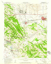
1953 Map of Livermore
USGS Topo · Published 1960About this map
Parks Air Force Base and the Naval Auxiliary Air Field anchor the northern landscape of this mid-century survey, reflecting the area's significant military presence. The valley floors are a hub of infrastructure and transit, where the Southern Pacific Railroad and Western Pacific Railroad intersect near Pleasanton and Livermore. This period shows the transition from agrarian roots to suburban development, with the U S Govt Nursery and County Fairgrounds situated alongside emerging residential grids.
Find a feature on this map
131 named features on this map. Tap any name to fly to it.
Don’t see what you’re looking for? This feature index may not catch every label — zoom into the map to look around manually.
Map Details
Editions of this 1953 Livermore Map
This is the sole edition of this map. No revisions or reprints were ever made.
Other maps of this area

1889 · San Jose
USGS Topo · 1:62,500

1896 · Mt. Diablo
USGS Topo · 1:62,500

1897 · San Jose
USGS Topo · 1:62,500

1897 · Mt. Hamilton
USGS Topo · 1:62,500

1897 · Concord
USGS Topo · 1:62,500

1897 · Palo Alto
USGS Topo · 1:62,500

1898 · Mt. Diablo
USGS Topo · 1:62,500

1899 · San Jose
USGS Topo · 1:62,500

1899 · Palo Alto
USGS Topo · 1:62,500

1899 · Haywards
USGS Topo · 1:62,500