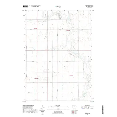
2018 Map of Livermore
USGS Topo · Published 2018About this map
Livermore sits at the northern edge of this Humboldt County survey, established near the confluence of Lotts Creek and the East Fork Des Moines River. The landscape is defined by the highly engineered water management systems characteristic of Iowa's agricultural heartland, where natural watercourses like Trulner Cr and Bloody Run are supplemented by man-made infrastructure such as Drainage Ditch Number 35 and Drainage Ditch Number 33. The map records the rural settlement of Arnold to the south and provides clear locations for genealogical research, including Mount Calvary Cem and Hands Grove Township Cem. The grid of county roads and avenues, such as Lincoln Ave and K Rd, illustrates the persistent township and range system that dictates the region's modern layout.
Find a feature on this map
45 named features on this map. Tap any name to fly to it.
Don’t see what you’re looking for? This feature index may not catch every label — zoom into the map to look around manually.
Map Details
Editions of this 2018 Livermore Map
This is the sole edition of this map. No revisions or reprints were ever made.
Other maps of this area

1923 · Fort Dodge
USGS Topo · 1:62,500

1954 · Fort Dodge
USGS Topo · 1:250,000

1957 · Fort Dodge
USGS Topo · 1:250,000

1958 · Fort Dodge
USGS Topo · 1:250,000

1972 · St. Joseph
USGS Topo · 1:24,000
1972 · Lu Verne
USGS Topo · 1:24,000

1972 · Livermore
USGS Topo · 1:24,000
1972 · Hardy
USGS Topo · 1:24,000
1979 · Thor
USGS Topo · 1:24,000

1979 · Humboldt
USGS Topo · 1:24,000