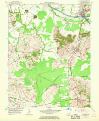
1952 Map of Livermore
USGS Topo · Published 1969About this map
The confluence of the Green River and Rough River defines the landscape of northern McLean County, where the town of Livermore serves as a focal point for commerce and river transport. This 1952 topographic survey reveals a region deeply tied to its natural waterways and early 20th-century industrial development, notably the numerous Oil Wells scattered across the northern and central sections. To the south, the Louisville and Nashville railroad cuts through the terrain, connecting the settlements of Island, Stroud, and Moorman.
Find a feature on this map
28 named features on this map. Tap any name to fly to it.
Don’t see what you’re looking for? This feature index may not catch every label — zoom into the map to look around manually.
Map Details
Editions of this 1952 Livermore Map
3 editions found
Other maps of this area

1906 · Sutherland
USGS Topo · 1:62,500

1908 · Calhoun
USGS Topo · 1:62,500

1909 · Madisonville
USGS Topo · 1:62,500

1909 · Central City
USGS Topo · 1:62,500

1952 · Equality
USGS Topo · 1:24,000

1952 · Livermore
USGS Topo · 1:24,000

1952 · Sacramento
USGS Topo · 1:24,000

1952 · Calhoun
USGS Topo · 1:24,000

1953 · Central City West
USGS Topo · 1:24,000

1953 · Central City East
USGS Topo · 1:24,000