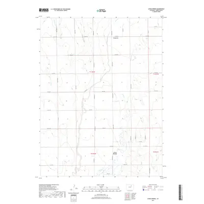
2019 Map of Living Springs
USGS Topo · Published 2019About this map
Kiowa Creek and its many intermittent tributaries define this high plains landscape in eastern Adams County. The settlement of Comanche sits at the intersection of E 160th Ave and Strasburg Rd, serving as a central point in an area largely characterized by broad drainage basins and seasonal watercourses like Comanche Creek and Lost Creek. The irrigation infrastructure of the Henrylyn Canal is visible in the northwest corner, cutting across the natural flow of Wolf Creek and Sand Creek. To the south, Living Springs marks a cluster of wetlands and ponds near the junction of Headlight Rd and E 112th Ave. The map reflects a rural grid system established for agriculture and ranching, with unique local names like Pass Me By Rd and Long Draw breaking the geometry of the section lines.
Find a feature on this map
35 named features on this map. Tap any name to fly to it.
Don’t see what you’re looking for? This feature index may not catch every label — zoom into the map to look around manually.
Map Details
Editions of this 2019 Living Springs Map
This is the sole edition of this map. No revisions or reprints were ever made.
Other maps of this area

1949 · Sunnydale
USGS Topo · 1:24,000

1949 · Bennett
USGS Topo · 1:24,000

1950 · South Roggen
USGS Topo · 1:24,000

1950 · Wiggins SW
USGS Topo · 1:24,000

1950 · Prospect Valley
USGS Topo · 1:24,000

1950 · Roper School
USGS Topo · 1:24,000

1951 · Prospect Valley
USGS Topo · 1:24,000

1951 · Roper School
USGS Topo · 1:24,000

1951 · Living Springs
USGS Topo · 1:24,000

1951 · Leader NW
USGS Topo · 1:24,000