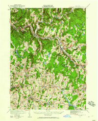
1921 Map of Livingston Manor
USGS Topo · Published 1960About this map
Livingston Manor and the surrounding Catskill landscape were defined by a robust timber-and-water-based industrial economy at the time of this 1920s survey. The New York Ontario and Western RR cuts through the river valleys, connecting specialized industrial sites like an Acid Plant, a Creosote Plant, and Dye Works that utilized local forest resources. The area is exceptionally dense with small rural school districts, naming local landmarks such as Ireland School, Weissman School, and Hardenburgh School. Higher elevations like Rattle Hill and Gray Hill overlook a network of glacial lakes including Tennanah Lake, Shandelee Lake, and Swan Lake. The mapping of small settlements like Callicoon Center, Jeffersonville, and Youngsville provides a clear view of the late-stage rural development in Sullivan County before significant 20th-century modernization changed the character of these hamlets.
Find a feature on this map
102 named features on this map. Tap any name to fly to it.
Don’t see what you’re looking for? This feature index may not catch every label — zoom into the map to look around manually.
Map Details
Editions of this 1921 Livingston Manor Map
2 editions found
Other maps of this area

1901 · Margaretville
USGS Topo · 1:62,500

1904 · Margaretville
USGS Topo · 1:62,500

1909 · Monticello
USGS Topo · 1:62,500

1910 · Neversink
USGS Topo · 1:62,500

1911 · Monticello
USGS Topo · 1:62,500

1920 · Long Eddy
USGS Topo · 1:62,500

1920 · Damascus
USGS Topo · 1:62,500

1921 · Long Eddy
USGS Topo · 1:48,000

1921 · Livingston Manor
USGS Topo · 1:62,500

1922 · White Lake
USGS Topo · 1:62,500