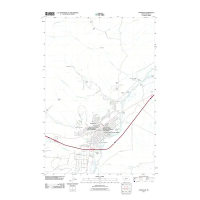
2011 Map of Livingston
USGS Topo · Published 2011About this map
Livingston dominates this landscape, showing a detailed network of residential expansions including Star Addition, Palace Addition, and the uniquely named Five Acre Tracts/Acreville Addition. The city is defined by its relationship to the Yellowstone River, which flows past landmarks like Siebeck Island and the Park County Fairgrounds. To the north and west, the terrain transitions into a mosaic of family-named agricultural operations such as Meigs Ranch, Tandy Ranch, and Mitchell Ranch, which follow the drainages of Ferry Creek and Slaughterhouse Creek. For those researching local history or genealogy, the map provides precise locations for the Mountainview Cemetery and Calvary Cemetery, as well as civic hubs like the Livingston Post Office and the Park Co Rural Fire Dist.
Find a feature on this map
122 named features on this map. Tap any name to fly to it.
Don’t see what you’re looking for? This feature index may not catch every label — zoom into the map to look around manually.
Map Details
Editions of this 2011 Livingston Map
This is the sole edition of this map. No revisions or reprints were ever made.
Other maps of this area

1891 · Livingston
USGS Topo · 1:250,000

1893 · Livingston
USGS Topo · 1:250,000

1947 · Bozeman
USGS Topo · 1:250,000

1948 · Bozeman
USGS Topo · 1:250,000

1951 · Gobblers Knob
USGS Topo · 1:24,000

1951 · Chadborn
USGS Topo · 1:24,000

1951 · Grannis
USGS Topo · 1:24,000

1951 · Brisbin
USGS Topo · 1:24,000

1951 · Hoppers
USGS Topo · 1:24,000

1951 · Livingston Peak
USGS Topo · 1:24,000