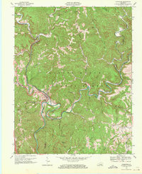
1969 Map of Livingston
USGS Topo · Published 1971About this map
The Rockcastle River snakes through the heart of the Daniel Boone National Forest, carving a deep path where the Louisville and Nashville RR and the Wilderness Road both sought passage through the Cumberland Plateau. In this 1969 revision, the town of Livingston serves as a critical junction for rail and river traffic, surrounded by a landscape defined by extractive industries and early frontier history. Numerous Mines and Strip Mines are scattered across the ridges, particularly near Mullins and the slopes of Wildcat Mountain. Significant cultural landmarks like the Great Saltpetre Cave and the Camp Wildcat Battle Monument indicate the long human history of this corridor. The map further documents a rural network of community life, evidenced by places like the Red Hill Sch, Fairview Ch, and family-named cemeteries such as Robinson Cem and Casteel Cem.
Find a feature on this map
69 named features on this map. Tap any name to fly to it.
Don’t see what you’re looking for? This feature index may not catch every label — zoom into the map to look around manually.
Map Details
Editions of this 1969 Livingston Map
2 editions found
Other maps of this area

1893 · London
USGS Topo · 1:125,000

1897 · London
USGS Topo · 1:125,000

1952 · Billows
USGS Topo · 1:24,000

1952 · Bernstadt
USGS Topo · 1:24,000

1952 · London
USGS Topo · 1:24,000

1953 · Johnetta
USGS Topo · 1:24,000

1953 · Sandgap
USGS Topo · 1:24,000

1953 · Wildie
USGS Topo · 1:24,000

1953 · Livingston
USGS Topo · 1:24,000

1953 · Mount Vernon
USGS Topo · 1:24,000