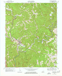
1969 Map of Livingston
USGS Topo · Published 1977About this map
Livingston stands as a focal point in this southern Kentucky landscape, situated where the Louisville and Nashville Railroad follows the winding course of the Rockcastle River. The town is framed by the steep topography of the Daniel Boone National Forest, characterized by numerous hollows like Hornsby Hollow and Mahaffey Hollow that drain into Roundstone Creek. Evidence of the region’s long history of passage is present in the Wilderness Road, while the Camp Wildcat Battle Monument marks a significant Civil War engagement site near Hoosier Knob.
Find a feature on this map
62 named features on this map. Tap any name to fly to it.
Don’t see what you’re looking for? This feature index may not catch every label — zoom into the map to look around manually.
Map Details
Editions of this 1969 Livingston Map
2 editions found
Other maps of this area

1893 · London
USGS Topo · 1:125,000

1897 · London
USGS Topo · 1:125,000

1952 · Billows
USGS Topo · 1:24,000

1952 · Bernstadt
USGS Topo · 1:24,000

1952 · London
USGS Topo · 1:24,000

1953 · Johnetta
USGS Topo · 1:24,000

1953 · Sandgap
USGS Topo · 1:24,000

1953 · Wildie
USGS Topo · 1:24,000

1953 · Livingston
USGS Topo · 1:24,000

1953 · Mount Vernon
USGS Topo · 1:24,000