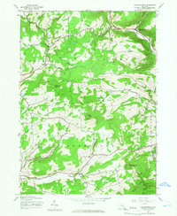
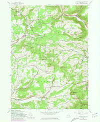
1945 Map of Livingstonville
USGS Topo · Published 1966About this map
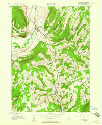
Catskill Creek and its tributaries define the upland landscape of Schoharie County in the years immediately following the Second World War. The area is characterized by a high density of rural schoolhouses, including School No 9 and School No 12, marking a network of small districts that anchored these mountain communities. The settlement pattern follows the narrow valley floors, with Livingstonville serving as a primary hub where the water meets the roadway. To the south, Conesville sits along the Manor Kill, overshadowed by the prominent heights of High Knob and Steenburg Mountain. This period shows a transition from traditional hillside farming toward a more reforested terrain, yet the map still identifies numerous local landmarks like the Scott Patent Ch and family-linked burial grounds such as Keyser Cem and Ellis Cem, which offer significant value for genealogists tracing old Schoharie and Albany County lines.
Find a feature on this map
34 named features on this map. Tap any name to fly to it.
Don’t see what you’re looking for? This feature index may not catch every label — zoom into the map to look around manually.
Map Details
Editions of this 1945 Livingstonville Map
2 editions found
Other maps of this area

1893 · Durham
USGS Topo · 1:62,500

1894 · Durham
USGS Topo · 1:62,500

1898 · Schoharie
USGS Topo · 1:62,500

1900 · Schoharie
USGS Topo · 1:62,500

1900 · Berne
USGS Topo · 1:62,500

1901 · Gilboa
USGS Topo · 1:62,500

1903 · Gilboa
USGS Topo · 1:62,500
1903 · Berne
USGS Topo · 1:62,500
1943 · Breakabeen
USGS Topo · 1:24,000
1944 · Middleburgh
USGS Topo · 1:24,000