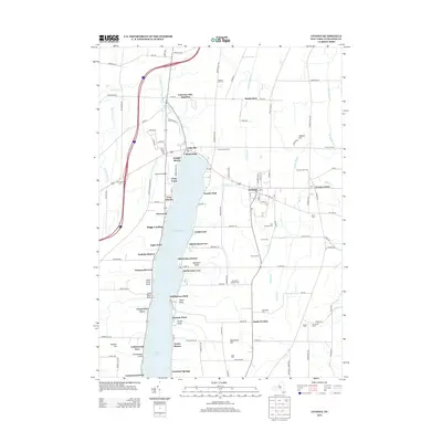
2013 Map of Livonia
USGS Topo · Published 2013About this map
Conesus Lake anchors this portion of Livingston County, serving as the focal point for a dense network of lakeside settlements and landings. From the northern reach at Lakeville and the Conesus Lake Junction, residential developments such as Pebble Beach, Graywood, and Cedarcrest line the eastern and western shores. The landscape transitions quickly from these active waterfront communities to the upland farms of the Genesee Valley, including Shooting Star Farm and Honeyhill Organic Farm. The village of Livonia serves as a central hub, connected to outlying hamlets like South Livonia and Livonia Center by a grid of rural roads. Genealogists will find a high density of burial sites throughout the township, from the centrally located Saint Michaels Cem and Union Cem to the family-named Harder Cem and Alger Cem positioned among the agricultural tracts.
Find a feature on this map
87 named features on this map. Tap any name to fly to it.
Don’t see what you’re looking for? This feature index may not catch every label — zoom into the map to look around manually.
Map Details
Editions of this 2013 Livonia Map
This is the sole edition of this map. No revisions or reprints were ever made.
Other maps of this area

1901 · Honeoye
USGS Topo · 1:62,500

1902 · Wayland
USGS Topo · 1:62,500

1904 · Wayland
USGS Topo · 1:62,500

1904 · Caledonia
USGS Topo · 1:62,500

1904 · Honeoye
USGS Topo · 1:62,500

1905 · Nunda
USGS Topo · 1:62,500

1934 · Rush
USGS Topo · 1:24,000
1934 · Honeoye Falls
USGS Topo · 1:24,000

1942 · Springwater
USGS Topo · 1:31,680
1942 · Honeoye
USGS Topo · 1:31,680