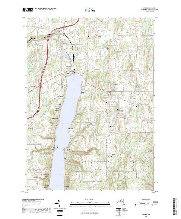
2023 Map of Livonia
USGS Topo · Published 2023About this map
Conesus Lake dominates this landscape, its western and eastern shores tightly lined with residential developments including Lakeville, Tuxedo Park, and Graywood. The terrain reflects a glacial legacy of north-south valleys and prominent ridges, such as Henderson Hill and Jakman Hill. The settlement pattern at Livonia and Livonia Center demonstrates the historical importance of the road and rail network, while the clustering of landings like Sleggs Landing and points like McPherson Point highlights the enduring appeal of the lakefront. Local heritage is preserved in numerous burial grounds, including the centrally located Saint Michaels Cem and the more remote Alger Cem to the south. Further inland, the map shows Lakeville Airport and the mineral-rich waters of Excelsior Springs, illustrating a mix of early 21st-century recreation and established rural infrastructure.
Find a feature on this map
98 named features on this map. Tap any name to fly to it.
Don’t see what you’re looking for? This feature index may not catch every label — zoom into the map to look around manually.
Map Details
Editions of this 2023 Livonia Map
This is the sole edition of this map. No revisions or reprints were ever made.
Other maps of this area

1901 · Honeoye
USGS Topo · 1:62,500

1902 · Wayland
USGS Topo · 1:62,500

1904 · Wayland
USGS Topo · 1:62,500

1904 · Caledonia
USGS Topo · 1:62,500

1904 · Honeoye
USGS Topo · 1:62,500

1905 · Nunda
USGS Topo · 1:62,500

1934 · Rush
USGS Topo · 1:24,000
1934 · Honeoye Falls
USGS Topo · 1:24,000

1942 · Springwater
USGS Topo · 1:31,680
1942 · Honeoye
USGS Topo · 1:31,680