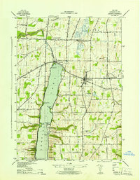
1942 Map of Livonia
USGS Topo · Published 1942About this map
Conesus Lake dominates the western landscape of this Livingston County region, its eastern shore punctuated by distinctive points such as Eagle Point, McPherson Point, and Old Orchard Point. In the early 1940s, the village of Livonia served as a central hub, where the Erie Railroad intersected with local routes like Penimite Road. The map reveals a deeply settled agricultural and lakeside community, indicated by numerous country schools like School No 2 and School No 5, and several small cemeteries including Mt Pleasant Cem and Oak Ridge Cem. To the north, the junction of the Lehigh Valley Railroad near Conesus Lake Junc illustrates the era's rail-dependent economy. Further south, lakeside life is marked by places like Cedarcrest and the Atwater Memorial Ch, showing the early 20th-century development of the waterfront.
Find a feature on this map
55 named features on this map. Tap any name to fly to it.
Don’t see what you’re looking for? This feature index may not catch every label — zoom into the map to look around manually.
Map Details
Editions of this 1942 Livonia Map
This is the sole edition of this map. No revisions or reprints were ever made.
Other maps of this area

1901 · Honeoye
USGS Topo · 1:62,500

1902 · Wayland
USGS Topo · 1:62,500

1904 · Wayland
USGS Topo · 1:62,500

1904 · Caledonia
USGS Topo · 1:62,500

1904 · Honeoye
USGS Topo · 1:62,500

1905 · Nunda
USGS Topo · 1:62,500

1934 · Rush
USGS Topo · 1:24,000
1934 · Honeoye Falls
USGS Topo · 1:24,000

1942 · Springwater
USGS Topo · 1:31,680
1942 · Honeoye
USGS Topo · 1:31,680